
Eifel
Laacher See Eruption
Wingertsbergwand
Location: 50.39 ° N, 7.28° E
Elevation: 290 m
The Laacher See volcano forms a volcanic caldera in the Eifel mountain range. It is part of the area
called "East Eifel volcanic field".The lake lies 259
m above sea level, is 8 km in circumference, and
surrounded by a ring of high hills. The water is
blue, very cold and bitter to the taste. The lake has
no natural outlet. The caldera was formed after the
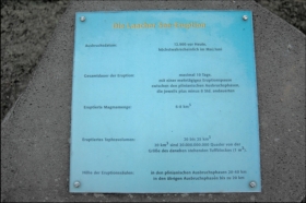
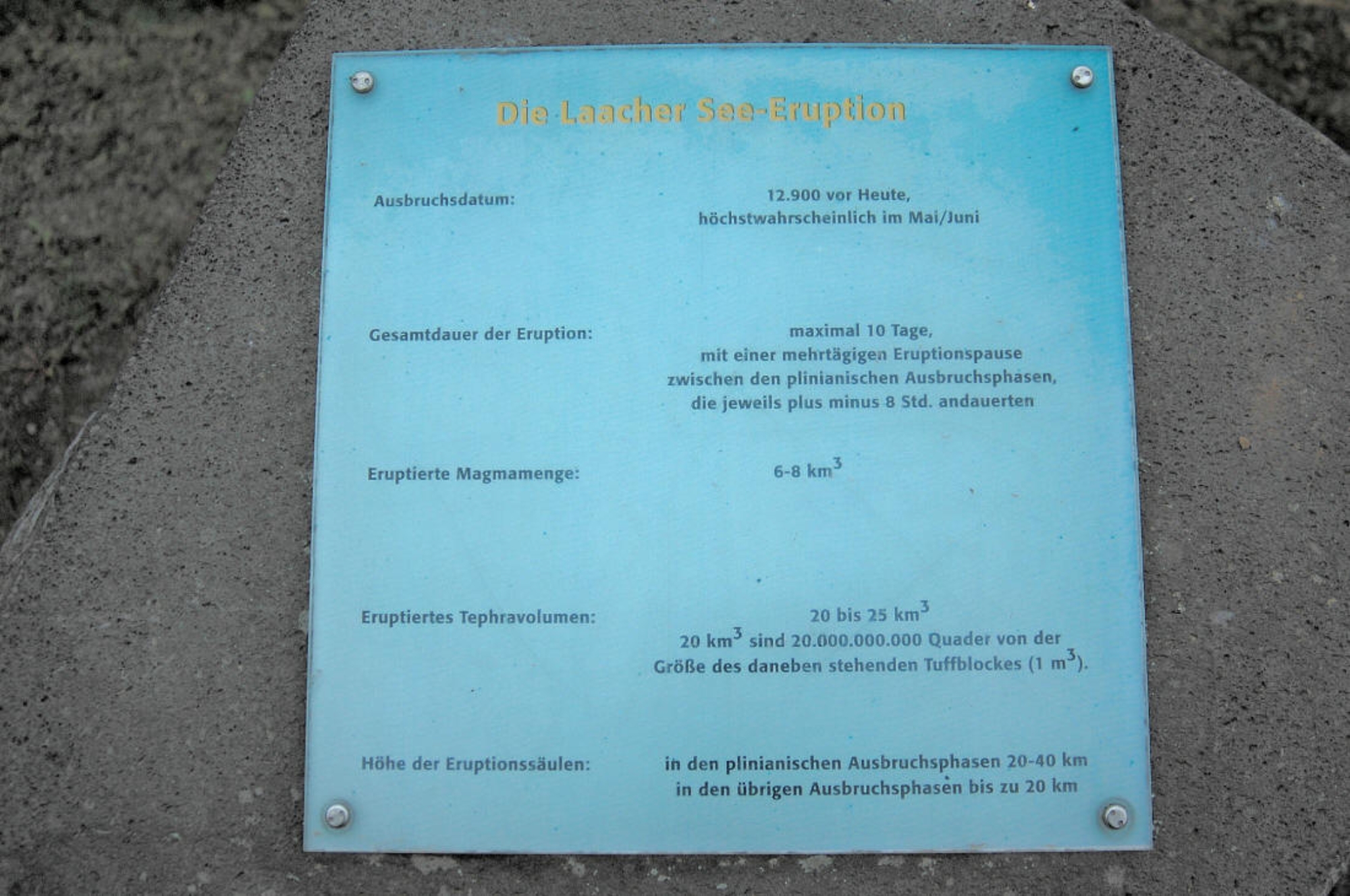
colossal Laacher See eruption dated to 12,900
years ago. The remaining crust collapsed into the
empty magma chamber below, probably two or
three days after the eruption. With an estimated 6
km³ of magma erupted, this massive eruption had a
VEI of 5. Tephra deposits from the eruption
dammed the Rhine, creating a 140 km2 lake. When
the dam broke, an outburst flood swept
downstream, leaving deposits as far away as Bonn.
The Wingertsbergvulkan is the outbreak center of the two Niedermendiger basalt lava streams
(Niedermendig is a part of the city Mendig). The mountain was originally 322 m high; it has since been
completely diminished. North of the Wingertsberg is the Wingertsbergwand, a wall up to 40 m high. One can
reconstruct on the basis several Tephrasequences that the enormous outbreak of the Laach lake volcano here
is unique. The Wingertsbergwand mountain belongs to the most beautiful and most well-known volcanic
explanations of the Eifel.
The Tephra deposits at the Wingertsberg is typical for so-called Pliniani eruptions - explosive outbreaks
which promote large quantities of volcanic ash. With the rocks in the Wingertsbergwand concerns around
deposits out of glow avalanches and the products of volcanic ashtray gene. The Tephra is particularly in the
lower part richly at large foreign rock inclusions, in particular at basalt in addition, at devonischem
basement.
The deposits from glow avalanches are irregularly and fibrously laminated, and show internal structures
which point to a rapid transport. One observes strong, rapidly changing grain size differences, with a general
trend to a finer grain size in the recent deposits. The fine sediments of Tuff in the highest layers represents
still the days after the outbreak raining ash particle.
in the Eifel mountain range. It is part of the area
called "East Eifel volcanic field".The lake lies 259
m above sea level, is 8 km in circumference, and
surrounded by a ring of high hills. The water is
blue, very cold and bitter to the taste. The lake has
no natural outlet. The caldera was formed after the
colossal Laacher See eruption dated to 12,900
years ago. The remaining crust collapsed into the
empty magma chamber below, probably two or
three days after the eruption. With an estimated 6
km³ of magma erupted, this massive eruption had a
VEI of 5. Tephra deposits from the eruption
dammed the Rhine, creating a 140 km2 lake. When
the dam broke, an outburst flood swept
downstream, leaving deposits as far away as Bonn.
The Wingertsbergvulkan is the outbreak center of the two Niedermendiger basalt lava streams
(Niedermendig is a part of the city Mendig). The mountain was originally 322 m high; it has since been
completely diminished. North of the Wingertsberg is the Wingertsbergwand, a wall up to 40 m high. One can
reconstruct on the basis several Tephrasequences that the enormous outbreak of the Laach lake volcano here
is unique. The Wingertsbergwand mountain belongs to the most beautiful and most well-known volcanic
explanations of the Eifel.
The Tephra deposits at the Wingertsberg is typical for so-called Pliniani eruptions - explosive outbreaks
which promote large quantities of volcanic ash. With the rocks in the Wingertsbergwand concerns around
deposits out of glow avalanches and the products of volcanic ashtray gene. The Tephra is particularly in the
lower part richly at large foreign rock inclusions, in particular at basalt in addition, at devonischem
basement.
The deposits from glow avalanches are irregularly and fibrously laminated, and show internal structures
which point to a rapid transport. One observes strong, rapidly changing grain size differences, with a general
trend to a finer grain size in the recent deposits. The fine sediments of Tuff in the highest layers represents
still the days after the outbreak raining ash particle.


 HOME
HOME