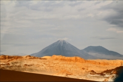
Licancabur
Summit Elevation: 5916 m
Latitude: 22.83°S
Longitude: 67.88°W
A classically symmetrical conical volcano, Licancabur has a circular basal plan with a
diameter of ~10 km, and appears to have
been largely constructed in post-glacial
times (compare the pre-Holocene Volcan
Juriques to the east). There is abundant
evidence of recent activity in the form of
youthful lava flows; a well preserved
summit crater, and an absence of glacial
geomorphic features. The cone is made
up predominantly of lavas interbedded
with minor pyroclastic deposits. Young
lavas are particularly well developed on
the western flanks of the volcano and extend for up to 6 km down the regional slope of
about 3° on which Licancabur is built. Levées and flow ridge morphologies are well
preserved on the thick (50-100m), blocky lava flows. Within the 400 m diameter summit
crater is a fresh water lake, about 90 m x 70 m. This is one of the highest lakes in the
world and hosts a planktonic fauna of considerable interest to biologists. A high altitude
diving expedition in 1984 found the lake to be <4m deep with a temperature of 6 °C at
the bottom. Ruins of archaeological interest are present on the rim of the crater.
Little is known about the earliest activity, but as with many of the other centres in this
region, the oldest lava flows extend considerably further than the youngest. Flows on the
west extend for ~12 km from the present centre and their distal portions divide into
several thin flows extending 1-3 km from the main lava body (~9 km from the volcano).
Flank lava flows are the most recent activity from this Licancabur. There are no records
of historic eruptions. (Volcano Wold)
Licancabur has a circular basal plan with a
diameter of ~10 km, and appears to have
been largely constructed in post-glacial
times (compare the pre-Holocene Volcan
Juriques to the east). There is abundant
evidence of recent activity in the form of
youthful lava flows; a well preserved
summit crater, and an absence of glacial
geomorphic features. The cone is made
up predominantly of lavas interbedded
with minor pyroclastic deposits. Young
lavas are particularly well developed on
the western flanks of the volcano and extend for up to 6 km down the regional slope of
about 3° on which Licancabur is built. Levées and flow ridge morphologies are well
preserved on the thick (50-100m), blocky lava flows. Within the 400 m diameter summit
crater is a fresh water lake, about 90 m x 70 m. This is one of the highest lakes in the
world and hosts a planktonic fauna of considerable interest to biologists. A high altitude
diving expedition in 1984 found the lake to be <4m deep with a temperature of 6 °C at
the bottom. Ruins of archaeological interest are present on the rim of the crater.
Little is known about the earliest activity, but as with many of the other centres in this
region, the oldest lava flows extend considerably further than the youngest. Flows on the
west extend for ~12 km from the present centre and their distal portions divide into
several thin flows extending 1-3 km from the main lava body (~9 km from the volcano).
Flank lava flows are the most recent activity from this Licancabur. There are no records
of historic eruptions. (Volcano Wold)


 click on Pictures to enlarge
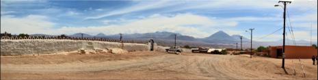
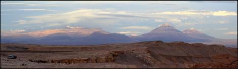
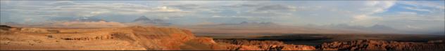
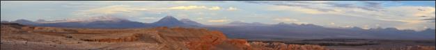
Panoramas
click on Pictures to enlarge
Panoramas
 click on panoramas
HOME
click on panoramas
HOME
Licancabur has a circular basal plan with a
diameter of ~10 km, and appears to have
been largely constructed in post-glacial
times (compare the pre-Holocene Volcan
Juriques to the east). There is abundant
evidence of recent activity in the form of
youthful lava flows; a well preserved
summit crater, and an absence of glacial
geomorphic features. The cone is made
up predominantly of lavas interbedded
with minor pyroclastic deposits. Young
lavas are particularly well developed on
the western flanks of the volcano and extend for up to 6 km down the regional slope of
about 3° on which Licancabur is built. Levées and flow ridge morphologies are well
preserved on the thick (50-100m), blocky lava flows. Within the 400 m diameter summit
crater is a fresh water lake, about 90 m x 70 m. This is one of the highest lakes in the
world and hosts a planktonic fauna of considerable interest to biologists. A high altitude
diving expedition in 1984 found the lake to be <4m deep with a temperature of 6 °C at
the bottom. Ruins of archaeological interest are present on the rim of the crater.
Little is known about the earliest activity, but as with many of the other centres in this
region, the oldest lava flows extend considerably further than the youngest. Flows on the
west extend for ~12 km from the present centre and their distal portions divide into
several thin flows extending 1-3 km from the main lava body (~9 km from the volcano).
Flank lava flows are the most recent activity from this Licancabur. There are no records
of historic eruptions. (Volcano Wold)


 click on Pictures to enlarge
Panoramas
click on panoramas
HOME
click on Pictures to enlarge
Panoramas
click on panoramas
HOME