


|

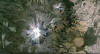
Pico de Orizaba, seen from flight Cozumel-Mexico City
Pico de Orizaba (Volcán Citlaltépetl), México's highest peak and North America's highest volcano, was formed in three stages beginning during the mid-Pleistocene. Orizaba lies at the southern end of a volcanic chain extending north to Cofre de Perote volcano and towers up to 4400 m above its eastern base. Construction of the initial Torrecillas and Espolón de Oro volcanoes was contemporaneous with growth of Sierra Negra volcano on the SW flank and was followed by edifice collapses that produced voluminous debris avalanches and lahars. The modern Citlaltépetl volcano was constructed during the late Pleistocene and Holocene of viscous andesitic and dacitic lavas, forming the current steep-sided cone. Repetitive explosive eruptions beginning during the early Holocene accompanied lava dome growth and lava effusion. Historical eruptions have consisted of moderate explosive activity and the effusion of dacitic lava flows. The latest eruption of the volcano occurred during the 19th century.(Global Volcanism Program)