


|

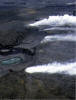
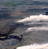
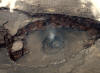
The Pu`u `Ō `ō-Kupaianaha eruption of Kīlauea ranks as the most voluminous outpouring of lava on the volcano's east rift zone in the past five centuries. Beginning in 1983, a series of short-lived lava fountains built the massive cinder-and-spatter cone of Pu`u `Ō `ō. In 1986, the eruption migrated 3 km down the east rift zone to build a broad shield, Kupaianaha. When the eruption shifted back to Pu`u `Ō `ō in 1992, flank-vent eruptions formed a shield banked against the west side of the cone. From 1992 to 2007, nearly continuous effusion from these vents has sent lava flows to the ocean, mainly inside the national park. Flank vent activity undermined the west and south sides of the cone, resulting in the collapse of the west flank in January 1997. Since 1997, the eruption has continued from a series of flank vents on the west and south sides of the Pu`u `Ō `ō cone. During this time the composite flow field has expanded westward, and tube-fed pahoehoe forms a plain that spans 15.6 km at the coast.