Wau-en-Namus
Location: 25.05°N, 17.55° E
Elevation: 547 m
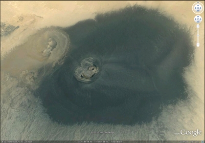
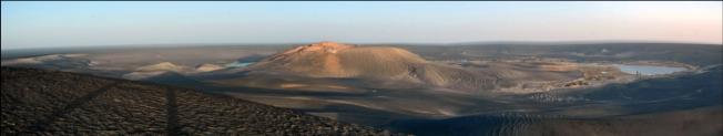
The isolated Wau-en-Namus volcanic field (also spelled Waw an Namous or
Uaw en Namus) lies in the Sahara
desert of south-central Libya, south of
the Haruj volcanic field. A 4-km-
wide, 100-m-deep caldera contains a
post-caldera scoria cone, Wau-en-
Namus. An apron of dark basaltic
tephra extends 10-20 km around the
caldera in stark contrast to the light-
colored desert sand prominent in
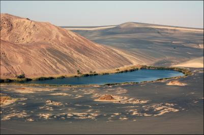
satellite views -the Dark Spot, as it appeared in Google Earth.Three small salt
lakes of variable color contribute to the name of the volcano, which means
"Oasis of Mosquitoes." The youthful appearance of the central cone has
suggested it may be as young as a few thousand years, although the arid climate
may mask its actual age. Yellow sulfur deposits are found in the 150-m-wide
crater. Other basaltic lava flows occur several tens of km NW of the volcano.
field (also spelled Waw an Namous or
Uaw en Namus) lies in the Sahara
desert of south-central Libya, south of
the Haruj volcanic field. A 4-km-
wide, 100-m-deep caldera contains a
post-caldera scoria cone, Wau-en-
Namus. An apron of dark basaltic
tephra extends 10-20 km around the
caldera in stark contrast to the light-
colored desert sand prominent in
satellite views -the Dark Spot, as it appeared in Google Earth.Three small salt
lakes of variable color contribute to the name of the volcano, which means
"Oasis of Mosquitoes." The youthful appearance of the central cone has
suggested it may be as young as a few thousand years, although the arid climate
may mask its actual age. Yellow sulfur deposits are found in the 150-m-wide
crater. Other basaltic lava flows occur several tens of km NW of the volcano.
 Panoramas
Photogallery
Panoramas
Photogallery
 HOME
HOME
field (also spelled Waw an Namous or
Uaw en Namus) lies in the Sahara
desert of south-central Libya, south of
the Haruj volcanic field. A 4-km-
wide, 100-m-deep caldera contains a
post-caldera scoria cone, Wau-en-
Namus. An apron of dark basaltic
tephra extends 10-20 km around the
caldera in stark contrast to the light-
colored desert sand prominent in
satellite views -the Dark Spot, as it appeared in Google Earth.Three small salt
lakes of variable color contribute to the name of the volcano, which means
"Oasis of Mosquitoes." The youthful appearance of the central cone has
suggested it may be as young as a few thousand years, although the arid climate
may mask its actual age. Yellow sulfur deposits are found in the 150-m-wide
crater. Other basaltic lava flows occur several tens of km NW of the volcano.
 Panoramas
Photogallery
HOME
Panoramas
Photogallery
HOME