2010 Kap Verde
 Ilha do Fogo
Panoramen
Chã das Caldeiras
Pico Perqueno
Pico do Fogo
Ilha do Fogo
Panoramen
Chã das Caldeiras
Pico Perqueno
Pico do Fogo

 HOME
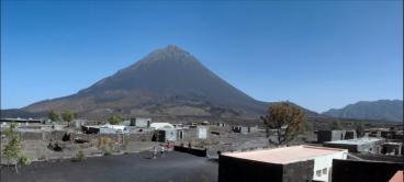
The island of Fogo consists of a single massive stratovolcano that is the
HOME
The island of Fogo consists of a single massive stratovolcano that is the most prominent of the Cape Verde Islands. The roughly circular 25-km-
wide island is truncated by a large 9-km-wide caldera that is breached to
the east and has a headwall 1 km high. The caldera (Chã das Caldeiras) is
located asymmetrically NE of the center of the island and was formed as a
result of massive lateral collapse of the ancestral Monte Armarelo edifice.
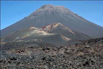
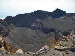
A very youthful steep-sided central cone, Pico, rises more than 1 km above
the caldera floor to about 100 m above the caldera rim, forming the 2829
m high point of the island. Pico, which is capped by a 500-m-wide, 150-m-
deep summit crater, was apparently in almost continuous activity from the
time of Portuguese settlement in 1500 AD until around 1760. Later
historical lava flows, some from vents on the caldera floor, reached the
eastern coast below the breached caldera. The last eruption on 2 April
1995, formed a small tributary volcano (Pico Pequeno 1,950 m) at the
western foot of the Pico, the lava flow limited to the interior of the Caldera.
Two small villages, called Portela and Bangaeira in the plain Chã das
Caldeiras, exists within the caldera of the volcano. After the outbreak of the
Pico Pequeno large parts of the cultural landscape were destroyed in the
Caldeira, the 2000 residents were temporarily evacuated.
most prominent of the Cape Verde Islands. The roughly circular 25-km-
wide island is truncated by a large 9-km-wide caldera that is breached to
the east and has a headwall 1 km high. The caldera (Chã das Caldeiras) is
located asymmetrically NE of the center of the island and was formed as a
result of massive lateral collapse of the ancestral Monte Armarelo edifice.
A very youthful steep-sided central cone, Pico, rises more than 1 km above
the caldera floor to about 100 m above the caldera rim, forming the 2829
m high point of the island. Pico, which is capped by a 500-m-wide, 150-m-
deep summit crater, was apparently in almost continuous activity from the
time of Portuguese settlement in 1500 AD until around 1760. Later
historical lava flows, some from vents on the caldera floor, reached the
eastern coast below the breached caldera. The last eruption on 2 April
1995, formed a small tributary volcano (Pico Pequeno 1,950 m) at the
western foot of the Pico, the lava flow limited to the interior of the Caldera.
Two small villages, called Portela and Bangaeira in the plain Chã das
Caldeiras, exists within the caldera of the volcano. After the outbreak of the
Pico Pequeno large parts of the cultural landscape were destroyed in the
Caldeira, the 2000 residents were temporarily evacuated.


Ilha do Fogo
Panoramen
Chã das Caldeiras
Pico Perqueno
Pico do Fogo
HOME
The island of Fogo consists of a single massive stratovolcano that is the
most prominent of the Cape Verde Islands. The roughly circular 25-km-
wide island is truncated by a large 9-km-wide caldera that is breached to
the east and has a headwall 1 km high. The caldera (Chã das Caldeiras) is
located asymmetrically NE of the center of the island and was formed as a
result of massive lateral collapse of the ancestral Monte Armarelo edifice.
A very youthful steep-sided central cone, Pico, rises more than 1 km above
the caldera floor to about 100 m above the caldera rim, forming the 2829
m high point of the island. Pico, which is capped by a 500-m-wide, 150-m-
deep summit crater, was apparently in almost continuous activity from the
time of Portuguese settlement in 1500 AD until around 1760. Later
historical lava flows, some from vents on the caldera floor, reached the
eastern coast below the breached caldera. The last eruption on 2 April
1995, formed a small tributary volcano (Pico Pequeno 1,950 m) at the
western foot of the Pico, the lava flow limited to the interior of the Caldera.
Two small villages, called Portela and Bangaeira in the plain Chã das
Caldeiras, exists within the caldera of the volcano. After the outbreak of the
Pico Pequeno large parts of the cultural landscape were destroyed in the
Caldeira, the 2000 residents were temporarily evacuated.
